


What's Up Newsletter: January 29
Blizzard Warning, Travel Ban, State of Emergency


Good Morning! Ryan Belmore here at 6:43 am on Saturday, January 29. Here’s the latest on the winter storm that’s significantly impacting Rhode Island today.
- - A Blizzard Warning is in effect until midnight tonight.
- - Governor McKee has declared a State of Emergency and there is a travel ban from 6 am until 11:59 pm for tractor-trailers and from 8 am until 8 pm for all other vehicles.
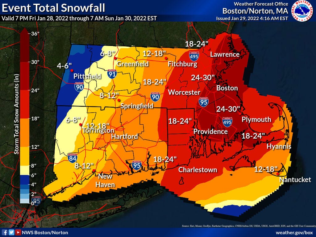
- - As of 4:16 am this morning, the National Weather Service is (still) saying we’re going to end up with 18-24” of total snow accumulation when this is all over.
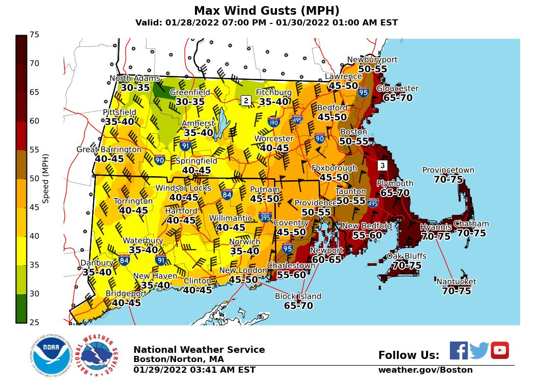
- - Unfortunately, they are also calling for winds gusts ranging from 45 - 65 mph for most of Rhode Island.
- - With high winds and heavy snow, comes power outages. Luckily, there are only 53 National Grid customers without power at this time. Unfortunately, 51 of those are in Newport County. Keep an eye on power outages throughout the storm here - LIVE BLOG | Rhode Island Power Outage Map
- - There are parking bans pretty much everywhere and just about everything (and every event) is canceled or delayed. Keep an eye on those updates here - LIVE BLOG | Rhode Island cancellations, closures, and delays
- - As always, What’s Up Newp is here for you. If you have a question, need help finding information or resources, want to share information with our audience, want to share photos or snow measurements, or anything else, email ryan@whatsupnewp.com or call/text 401-662-1653.
Stay safe and warm out there,
~ Ryan
P.S. - The Weather Channel has had a reporter live on the ground in Newport all morning. If you need a reminder of what it’s like outside your door, tune on in for the live reports.

The Latest from WUN
Just My Opinion: Reaching out during Blizzard of 2022
UPDATED: Blizzard Warning in effect – 18 – 24″ of snow, wind gusts of 45 – 70 mph expected
LIVE BLOG | Rhode Island cancellations, closures, and delays
Snow Report: Mountain Conditions at New England Ski Resorts
Weather: Today, Tonight & Tomorrow’s Weather Forecast for Newport, RI
Gerry Goldstein: Sen. Marshall’s `B.S.’ degree tells the whole story
Governor McKee declares State of Emergency, announces there will be a Travel Ban on Saturday
Snow Forecast Roundup – PM Edition: Here’s how much snow is expected to fall in Rhode Island
What’sUpNewp’s top stories this week in Newport County
Saturday performances of “Jesus Christ Superstar” at PPAC cancelled due to storm
Congrats: Brook Hopper, of Jamestown, graduates from The University of Tampa
8 Open Houses to check out in Newport County this weekend (Jan. 28 -30)
How is snowfall measured? A meteorologist explains how volunteers tally up winter storms
City of Newport issues parking ban ahead of Winter Storm
Snow Forecast Roundup – AM Edition: Here’s how much snow is expected to fall in Rhode Island
What is a bomb cyclone? An atmospheric scientist explains
Poll: Where is the best place to go sledding on Aquidneck Island?
Best places to go sledding and tubing on Aquidneck Island
Trending on WUN Right Now
Snow Forecast Roundup - AM Edition: Here's how much snow is expected to fall in Rhode Island
UPDATED: Blizzard Warning in effect - 18 - 24" of snow, wind gusts of 45 - 70 mph expected
LIVE BLOG | Rhode Island cancellations, closures, and delays
What’s Up Out There
Weather
Hazardous Weather Outlook
Blizzard Warning
Today: Snow. The snow could be heavy at times. Areas of blowing snow after noon. Temperature falling to around 23 by noon. Windy, with a north wind 28 to 32 mph, with gusts as high as 60 mph. The chance of precipitation is 100%. Total daytime snow accumulation of 11 to 17 inches possible.
Tonight: A chance of snow, mainly before 8 pm. The snow could be heavy at times. Areas of blowing snow. Cloudy during the early evening, then gradual clearing, with a low around 12. Wind chill values as low as -4. Blustery, with a northwest wind 17 to 24 mph, with gusts as high as 40 mph. The chance of precipitation is 30%. New snow accumulation of less than one inch possible.
Sunday: Sunny, with a high near 25. Wind chill values as low as -4. West wind 10 to 15 mph, with gusts as high as 25 mph.
Sunday Night: Mostly clear, with a low around 14. West wind 5 to 9 mph becoming light northwest after midnight.
Marine Forecast
Storm Warning in effect from January 29, 04:00 AM EST until January 30, 12:00 AM EST
Today - N wind 25 to 28 kt, with gusts as high as 55 kt. Snow with areas of blowing snow. The snow could be heavy at times. Seas 1 ft or less.
Tonight - NW wind 18 to 21 kt decreasing to 15 to 18 kt after midnight. Winds could gust as high as 35 kt. Areas of blowing snow and a chance of snow before 8pm, then areas of blowing snow and a slight chance of snow between 8pm and 10pm, then areas of blowing snow after 10pm. The snow could be heavy at times. Seas 1 ft or less.
Coastal Water Temperature: 42°F.
Sun, Moon, & Tide
Sunrise: 6:59 am | Sunset: 4:57 pm | 9 hours & 57 minutes of sun.
High tide at 4:57 am & 5:24 pm | Low tide at 11:23 am & 10:50 pm.
Moon: Waning Crescent, 25.9 days, 14% lighting.
Things To Do
Just everything has been canceled for today, but here’s what was up this weekend.
Shovel.
Rest.
Read.
Shovel.
Check on a loved one.
We’ll See You Out There
